


New Hampshire Tide Chart app for iPhone and iPad
Accurate, simple to use Satellite Map based New Hampshire tide charts of the all NOAA based New Hampshire tide stations on a simple to use satellite map. Designed by New Hampshire fishermen and Professional New Hampshire Fishing Guides.
NO SPAM ADS, SIMPLE TO USE...100% AD FREE.
Other Features:
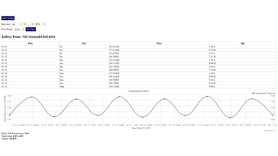
Ability to forecast New Hampshire tides from NOAA by setting date and period for any of the tidal stations for the entire State of New Hampshire tide tables.
Excellent support for any issues, questions or new features...simply email: [email protected] and well show you how Apple support is meant to be.
Auto-save last location for easy reference to your last tide station the next time you use the tide app.
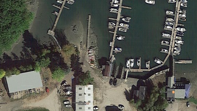
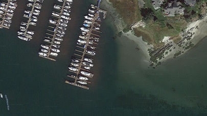
Included is the ability to zoom and view satellite imagery for fishing ground characteristics to compare with tide movement.
Advanced tide graphs allow for you to judge the level of water movement for optimal fishing between high and low tide in New Hampshire between tide stations so you can follow the tide flow for the entire day.
Recent Feedback:
"NesTides ability to display tide predictions and actual tidal flow graphs allow me to extend fishing trips by following different tide station tide charts and moving with the tide flow. The satellite view allows me to explore and discover new fishing grounds I never knew existed. Absolutely the best fishing software tool I have ever used. ," said USCG Captain Mike K.
New Hampshire Tide Chart stations include (partial list see website for full list):
Jaffrey Point, Gerrish Island, Fort Point, Kittery Point, Seavey Island, Portsmouth, Atlantic Heights, Dover Point, Dover, Cocheco River, Salmon Falls River, Squamscott River RR. Bridge, Gosport Harbor, Isles of Shoals, Hampton Harbor